Welcome!
Welcome to the online feedback pages for the Duke Street Land Use Plan Framework Plan. To provide feedback:
- Interactive Maps: Use the tabs below to switch between the interactive maps showing the topic you are interested in (Mobility, Parks, Land Use, Building Heights) and use the "Add Marker" button to leave a comment.
- General Comment: If you have a broader or overall comment, please use the comment box at the bottom of the page.
- Question: If you have a question, please use the Q&A feature located at the bottom of the page.
The information contained on this page was first shared with the community on Wednesday, April 22. In addition to this page, you can find a recording of the meeting, as well as PDFs of all the relevant maps, on our project webpage: www.alexandriava.gov/DukeStreetPlan.
Stay tuned for more engagement opportunities coming up! The Framework Plan will be shared again with additional opportunities to review and ask questions at our in-person Community Meetings #6 and #7, with more information released closer to the date of each meeting:
- Community Meeting #6, in-person: May 28, Housing and Health (in-person, Patrick Henry Rec. Center)
- Community Meeting #7, in-person: June TBD, Parks, Transportation, and Sustainability (in-person, location TBA)
Questions? Contact Christian Brandt, Urban Planner, christian.brandt@alexandriava.gov, 703.746.3859
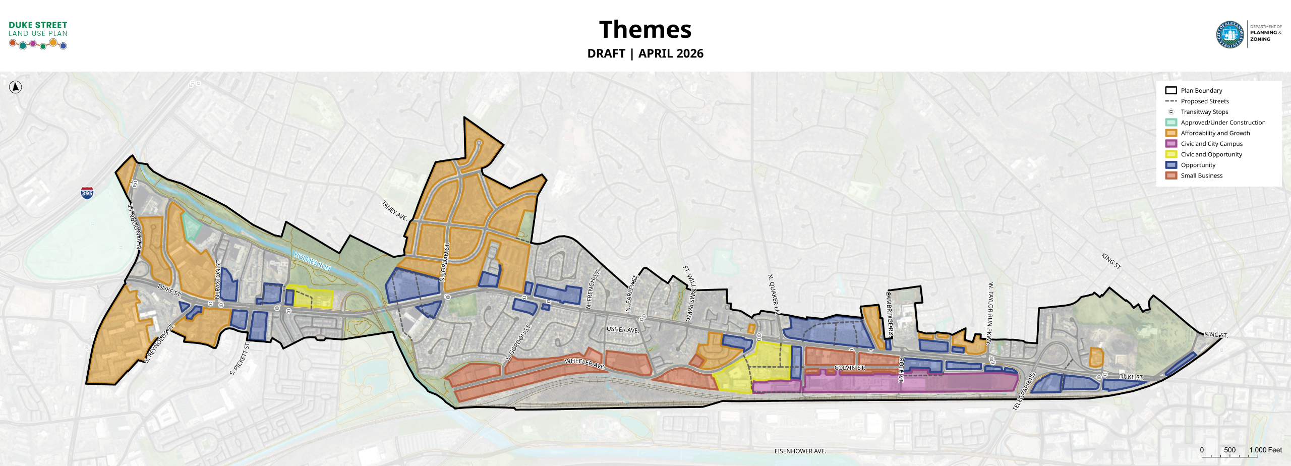
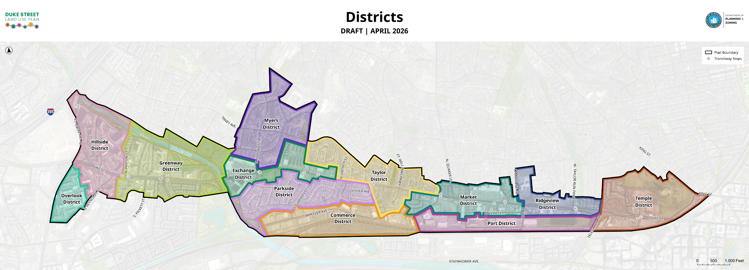
Districts and Themes Maps
Districts and Land Use Themes Maps
Land Use Themes: These apply the Draft Guiding Principles geographically. They consider the existing shared characteristics of areas throughout the corridor.
Districts: Based on existing character and land use patterns, the Districts will help organize land use recommendations around discrete geographic areas in the Corridor.
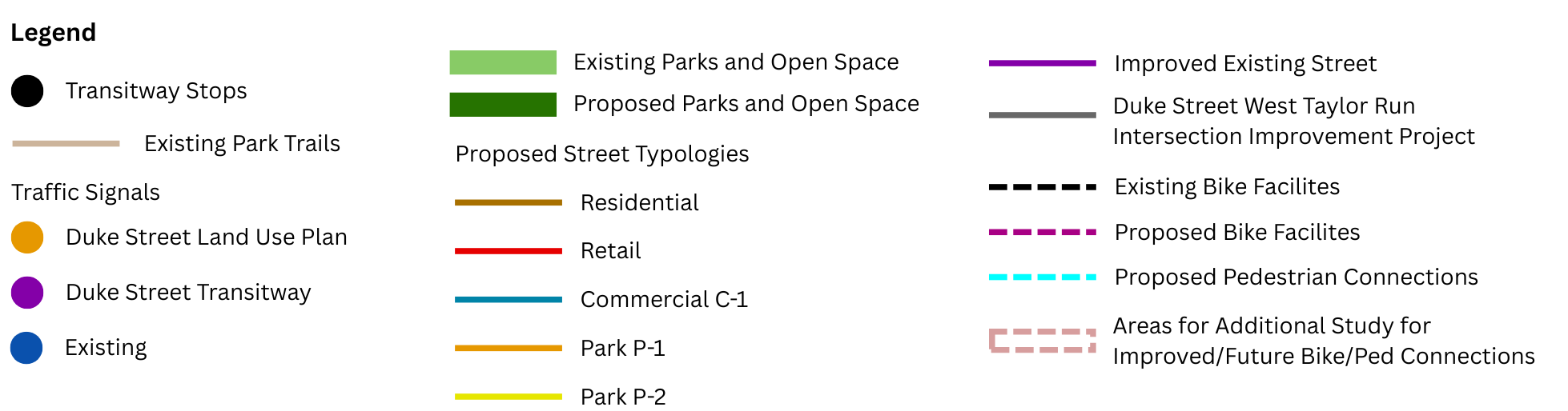
Mobility Network
![]() These communities, Foxchase and Mason at Van Dorn offer important housing affordability resources for the City and the Plan area. The City continues to coordinate with the property owner(s) regarding Plan recommendations to advance housing affordability strategies.
These communities, Foxchase and Mason at Van Dorn offer important housing affordability resources for the City and the Plan area. The City continues to coordinate with the property owner(s) regarding Plan recommendations to advance housing affordability strategies.
Existing Trails - A trail is a pedestrian pathway (paved or unpaved) typically narrower than a greenway. Typically located within natural areas and public parks.
Existing Parks and Open Spaces - Publicly-accessible parks and open spaces that already exist in the Plan Area.
Proposed Parks and Open Spaces - Publicly-accessible parks and open spaces that are proposed by the Plan to expand/connect existing parks and open space network.
Transitway Stops – Transit stops proposed as part of the approved Duke Street Transitway.
Traffic Signals – Three categories:
- Duke St Land Use Plan – Proposed signals that would occur with redevelopment to align with proposed new streets
- Duke St Transitway – Proposed signals as part of approved Duke St Transitway
- Existing – Signals currently in place and operating today.
Existing Bike Facilities – Existing bike lanes, sharrows, or multi-use trails.
Proposed Bike Facilities – Proposed bike lanes, sharrows, or multi-use trails, including facilities previously approved in the Alexandria Mobility Plan and other City plans as well as new ones proposed as part of this planning effort.
Proposed Pedestrian Connections – Proposed trails or paths that connect to other existing trails, paths, or sidewalks.
Areas for Additional Study for Improved/Future Bike/Ped Connections – Areas where no changes are currently proposed, but should be studied in the future for potential improvements.
Proposed Street Typologies – Multiple categories that will correspond in the future to street layouts with unique streetscapes (i.e. different widths for landscape, sidewalks, parking, etc.).
- Residential – Generally more residential/narrower; may accommodate parking or bike lanes.
- Retail – Generally wider with on-street parking, wider sidewalks that can support retail foot traffic and outdoor retail uses.
- Commercial C-1 – Located within small business and city campus areas. Generally constrained in width and may have limited ability, unless there is redevelopment, to improve existing streetscape.
- Park P-1 and P-2– Adjacent to proposed greenways or open spaces.
- Improved Existing Street Existing streets that will be upgraded over time, particularly as adjacent properties redevelop.
- Duke Street West Taylor Run Intersection Improvement Project – Approved Improvement Project for a new access ramp to Telegraph Road (https://www.alexandriava.gov/transportation-planning/duke-street-and-west-taylor-run-project).

Parks and Open Space Network
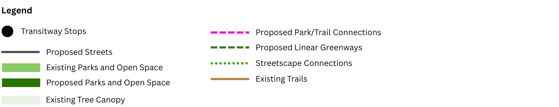
Map Notes
- The size, shape and location of the park(s) are illustrative. The final shape and location will be determined as part of the development process subject to the size and amenities recommended by the Plan.
- Planned improvements are based on development occurring to implement the Plan recommendations.
- The City will locate a new City recreation center, or similar facility, within the Plan area. City recreational facilities may be located within the public open spaces recommended by the Plan.
- Where existing parks are affected, equivalent open space will be relocated and reestablished at appropriate locations.
- Explore additional pedestrian and bicycle connections, where feasible, to improve access to parks.
- The City will work with the property owner to add pedestrian and bicycle connections from the Plan Area to WestEnd development if feasible.
- To further reinforce the Small Business Area, the City will pursue placemaking opportunities along Wheeler Ave.
![]() The City will work with property owners to evaluate opportunities to incorporate additional public open space.
The City will work with property owners to evaluate opportunities to incorporate additional public open space.
![]() These communities, Foxchase and Mason at Van Dorn offer important housing affordability resources for the City and the Plan area. The City continues to coordinate with the property owner(s) regarding Plan recommendations to advance housing affordability strategies.
These communities, Foxchase and Mason at Van Dorn offer important housing affordability resources for the City and the Plan area. The City continues to coordinate with the property owner(s) regarding Plan recommendations to advance housing affordability strategies.
Proposed Streets – Streets that are proposed as part of the mobility network and would be built during any potential redevelopment.
Transitway Stops - Transit stops that are proposed with the approved Duke Street Transitway.
Proposed Parks and Open Spaces - Publicly-accessible parks and open spaces that are proposed to help expand and connect the existing parks and open space network.
Existing Parks and Open Spaces - Publicly-accessible parks and open spaces that already exist in the Plan Area.
Existing Tree Canopy - Areas covered by existing tree canopy.
Proposed Park/Trail Connections - Proposed off-street connections that connect existing and proposed parks along the corridor.
Proposed Linear Greenways – Wide, pedestrian pathway with green spaces on either side. In some cases may be adjacent to buildings or public park/open space on one side.
Streetscape Connections - Connections between parks that utilize both existing sidewalks and enhanced sidewalks proposed as part of the Plan.
Existing Trails - A trail is a pedestrian pathway that is typically narrower than a greenway and may or may not be paved. Trails are typically located within wooded natural areas and public parks.
Land Uses
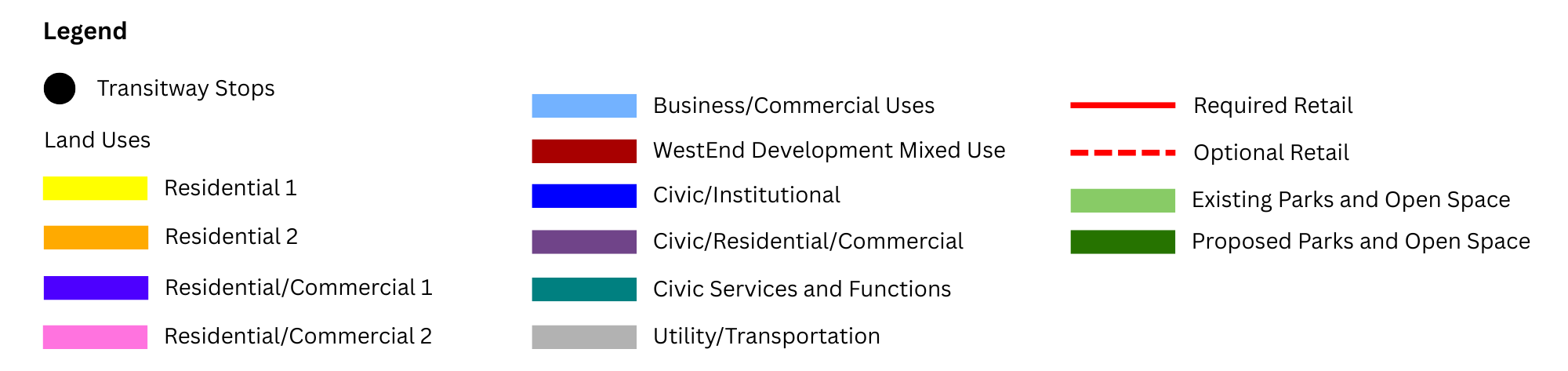
Map Notes
- Residential development within the opportunity area will be predominantly multi-unit development, with some limited townhouse/stacked townhouse development.
- City uses can be located within any of the land uses.
- Home for the Elderly and other comparable senior-serving uses are permitted.
- For Cameron Station, see CDD#9 for building heights guidance.
- The final design and configuration of the public open spaces/parks will be subject to the intent of the Plan.
![]() The City will work with property owners to evaluate opportunities to incorporate additional public open space.
The City will work with property owners to evaluate opportunities to incorporate additional public open space.
![]() Additional density/height will be permitted within all areas of the Affordability and Growth Land Use Area for the provision of committed affordable units.
Additional density/height will be permitted within all areas of the Affordability and Growth Land Use Area for the provision of committed affordable units.
![]() These communities, Foxchase and Mason at Van Dorn offer important housing affordability resources for the City and the Plan area. The City continues to coordinate with the property owner(s) regarding Plan recommendations to advance housing affordability strategies.
These communities, Foxchase and Mason at Van Dorn offer important housing affordability resources for the City and the Plan area. The City continues to coordinate with the property owner(s) regarding Plan recommendations to advance housing affordability strategies.
Residential 1 - Examples include garden apartments, single-unit, two-unit, and townhouses. Lower density than residential 2.
Residential 2 – Examples include multi-unit apartment and condominium buildings.
Residential/Commercial 1 - Smaller-scale commercial and Residential 1 typologies. Lower density than residential/commercial 2.
Residential/Commercial 2 - Flexible land uses for new development
Business/Commercial Uses – Small scale commercial uses that promote existing small businesses
Mixed Use (WestEnd) - Mix of uses allowed for the redevelopment of the former Landmark Mall. See Landmark/Van Dorn Corridor Plan.
Civic/Institutional - Use that includes public or private civic uses such as schools and civic buildings
Civic/Residential/Commercial - Mix of uses that allow for civic uses along with residential and/or commercial uses
Civic Services and Functions - Land areas that allow for city operations, maintenance and storage of City vehicles, and City administrative offices.
Utility/Transportation - Infrastructure and facilities that support utilities and transportation systems, such as power, water, transit, and roadway infrastructure
Required Retail - Uses that will have required ground-floor retail frontage
Optional Retail - Uses where ground-floor retail will be encouraged.
Proposed Parks and Open Spaces - Publicly-accessible parks and open spaces that are proposed to help expand and connect the existing parks and open space network.
Existing Parks and Open Spaces - Publicly-accessible parks and open spaces that already exist in the Plan Area.
Proposed Streets - Streets that are proposed as part of the mobility network and would be built during any potential redevelopment.
Transitway Stops - Transit stops that are proposed with the approved Duke Street Transitway.
Building Heights
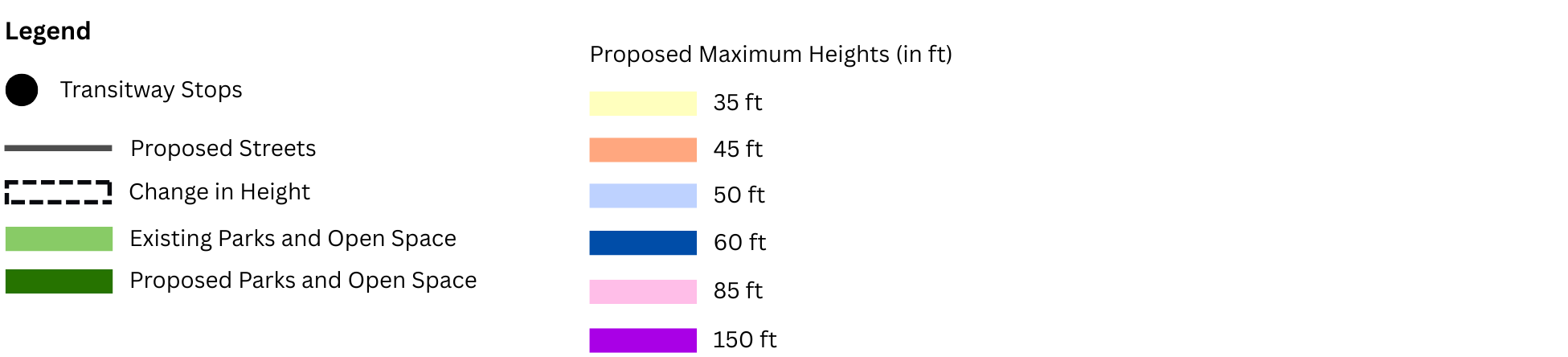
Map Notes
- Existing constructed heights above Plan Maximum Heights are permitted to remain, renovate, or convert use, subject to all applicable Zoning Ordinance provisions.
- All building heights within public open spaces/parks will be subject to all applicable provisions of the Public Open Space (POS) zone and Zoning Ordinance and applicable CDD recommendations.
- The final design and configuration of the public open spaces/parks will be subject to the intent of the Plan.
- For Cameron Station, see CDD#9 for building heights guidance.
- The rail corridor and associated parcels will be limited to a maximum height of 50 feet, as provided in the Utility/Transportation (UT) zone.
![]() The City will work with property owners to evaluate opportunities to incorporate additional public open space.
The City will work with property owners to evaluate opportunities to incorporate additional public open space.
![]() Additional density/height will be permitted within all areas of the Affordability and Growth Land Use Area for the provision of committed affordable units.
Additional density/height will be permitted within all areas of the Affordability and Growth Land Use Area for the provision of committed affordable units.
![]() These communities, Foxchase and Mason at Van Dorn offer important housing affordability resources for the City and the Plan area. The City continues to coordinate with the property owner(s) regarding Plan recommendations to advance housing affordability strategies.
These communities, Foxchase and Mason at Van Dorn offer important housing affordability resources for the City and the Plan area. The City continues to coordinate with the property owner(s) regarding Plan recommendations to advance housing affordability strategies.
Proposed Streets - Streets that are proposed as part of the mobility network and would be built during any potential redevelopment.
Transitway Stops - Transit stops that are proposed with the approved Duke Street Transitway.
Proposed Parks and Open Spaces - Publicly-accessible parks and open spaces that are proposed to help expand and connect the existing parks and open space network.
Existing Parks and Open Spaces - Publicly-accessible parks and open spaces that already exist in the Plan Area.
Framework Plan Q&A
To ask a question you must create an account or log in.
These are the people that are listening and responding to your questions.
Christian Brandt
Urban Planner
{{question.description}}
6 June, 2026
Tom says:
Cameron Station is a neighborhood, not a transit throughway or cut-through for Duke St. Leave our neighborhood as designed: a neighborhood.
6 June, 2026
Tom says:
Focus FIRST on solving Quaker-to-Telegraph backups…THE top priority. Hurts our businesses & residents. Bike lanes-nice, but, low priority.
28 May, 2026
Agnes says:
We desperately need a solution for the car traffic backups between Telegraph Road and Quaker Lane. Revisit the Connector to Eisenhower Ave.
26 May, 2026
Ralph says:
I would love to see increased building height limits across all residential zones! Denser housing makes Alexandria greener!
24 May, 2026
EC says:
Pls add bike lanes along Duke St & within Cameron Station. With double lanes in CS, ppl drive too fast- unsafe for all the walkers+bikers.
23 May, 2026
Tom V says:
I avoid Duke Street entirely because it's really only usable by car. Really need more protected bike lanes and safe pedestrian crossings!
21 May, 2026
Sandra B says:
Considering the high traffic volume on Duke street between S. Quaker and telegraph ramp, what is the plan for pedestrians to cross safely?
19 May, 2026
Ian says:
I would like to see a combination of housing alongside commercial whenever possible. Increased height limits and protected bike lanes too
13 May, 2026
ALXresident says:
We can beautify the area and create more visually appealing additions to the west end. Perhaps there can be a task force for this.
30 April, 2026
William says:
I hope to see protected bike/scooter lanes running the whole length of Duke Street to make it safe to use by any mode.
30 April, 2026
Asa says:
We need bike/scooter connectivity and walkability. I’m sick of kids being hit at the end of my street or across the street at Fox Chase.
24 April, 2026
Brianna says:
I think it's important to have safe and accessible bus lines, safe bike infrastructure, and safe walking